Weather
Chicago-Area Weather: Summer-Like Temps and Storms
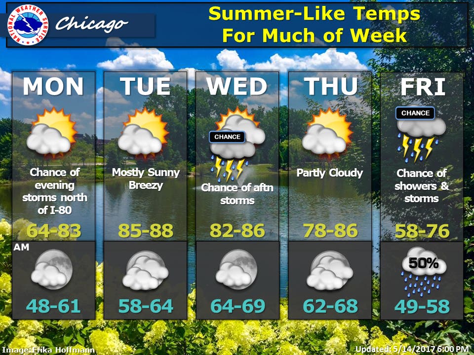
A look at the weather forecast for the coming week.


The Chicago area is going to get a dose of summer-like temperatures this week. On Monday through Thursday, high temps could reach into the lower- to upper-80s for portions of the Chicago area. Periodic chances for showers and thunderstorms are also in the forecast throughout the week.
On Sunday night, a small area of light showers is expected to move across northeast Illinois, according to the National Weather Service. The rain could hit between 10:30 and 11:30 p.m. and is expected to affect a line of town from just northeast of Rockford to Chicago.
A few rumbles of thunder are also possible.
Find out what's happening in Chicagowith free, real-time updates from Patch.
There is also a chance for storms Monday evening north of Interstate 80 and also a chance for storms across the Chicago area Wednesday afternoon and on Friday, according to the National Weather Service.
Find out what's happening in Chicagowith free, real-time updates from Patch.
But when it isn't raining, most of the week is expected to see mostly sunny or partly cloudy skies and hot weather. High temps will range from 64 to 83 degrees on Monday and could hit between 85 and 88 degrees on Tuesday, between 82 and 86 degrees on Wednesday and between 78 and 86 degrees on Thursday.
On Friday, temps will drop off with highs between 58 and 76 degrees.
Here is a more detailed look at the forecast for the coming week:
- TONIGHT: Partly cloudy. Lows in the lower 50s. East winds 5 to 10 mph.
- MONDAY: Partly cloudy. Highs around 80 inland...but only in the 60s near the lake. Southeast winds 10 to 15 mph.
- MONDAY NIGHT: Partly cloudy with a 30 percent chance of showers and thunderstorms. Lows in the lower 60s. South winds 10 to 15 mph.
- TUESDAY: Partly cloudy in the morning then clearing. Breezy. Highs in the mid 80s. South winds 10 to 15 mph in the morning increasing to 15 to 25 mph in the afternoon. Gusts up to 35 mph.
- TUESDAY NIGHT: Partly cloudy. Lows in the upper 60s. South winds 10 to 20 mph. Gusts up to 30 mph in the evening.
- WEDNESDAY: Partly sunny. A 20 percent chance of showers and thunderstorms in the afternoon. Highs in the mid 80s.
- WEDNESDAY NIGHT: Partly cloudy with a 30 percent chance of showers and thunderstorms in the evening, then mostly clear after midnight. Lows in the mid 60s.
- THURSDAY: Mostly sunny in the morning then becoming partly cloudy. Highs in the lower 80s.
- THURSDAY NIGHT: Partly cloudy. Lows in the lower 50s.
- FRIDAY: Mostly cloudy. Chance of showers in the afternoon. Highs in the upper 60s inland...but only in the upper 50s near the lake. Chance of precipitation 30 percent.
- FRIDAY NIGHT: Mostly cloudy with a 40 percent chance of showers and thunderstorms. Lows in the lower 50s.
Get more local news delivered straight to your inbox. Sign up for free Patch newsletters and alerts.


